
Rating value is 5 of 5
AIR TEAM Wire Harness COM/NAV COM/NAV Custom Wire Harness
COM/NAV Custom Wire Harness
Usually 1 week
Price from $ 551.12
$ 551.12 excl. VAT

The next era of global ADS-B. Compatible with both ground-based and space-based ADS-B surveillance systems, tailBeaconX is a Mode S Extended Squitter ADS-B transponder and WAAS GPS integrated into an LED rear position light. With global compliance, tailBeaconX is the key to limitless destinations. Expand the functionality of tailBeaconX and your panel when you pair it with the AV-30 as the control head for tailBeaconX. The AV-30 also functions as a primary AI or DG digital display with additional features for limitless possibilities.
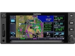
If you’ve flown with our earlier GNS™ 430 and GNS 530 series avionics, you’ll find that the menus of the GTN 650 have a familiar layout and feel. However, with the GTN 650 touchscreen interface, you’re rarely more than two taps away from all of the system’s primary functions. The large, easy-to-use alphanumeric keypad makes data entry a breeze. Pilot-selectable data fields and shortcuts allow you to quickly reach the information you need most. Just like pinch-to-zoom scaling on a smartphone or tablet, you can use your fingers to zoom in and out on any map, traffic, or terrain page. You can quickly pan across the moving map by swiping across the 4.9" high-resolution TFT display or enter waypoint data with the onscreen keypad.
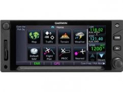
The GTN family makes it easier than ever to get where you’re going. Graphical flight planning capabilities enable you to edit your entire route on the map screen and easily add new waypoints or modify existing ones. The system even lets you load Victor and jet airways. A handy “rubber band” feature lets you grab any leg of your flight plan route and move it to accommodate a deviation or ATC amendment to your flight plan.
In IFR conditions, you now have more landing options as well. The 15-channel SBAS/WAAS-certified GPS receiver generates five position updates per second, enabling you to fly GPS-guided LPV glidepath instrument approaches down to as low as 200 feet. The system also includes a complete package of VHF navigation capabilities, with a 200-channel VOR/ILS with localizer and glideslope. When you load procedures, the GTN 650 will preload the NAV frequencies for you to manually switch to, and you can auto-select the VHF NAV source for ILS approaches. In addition, precise course deviation and roll steering outputs can be coupled with selected autopilots, so IFR flight procedures may be flown automatically.
A fully certified, 2,280-channel VHF communications transceiver provides a standard 10 W (or optional 16 W) of power output. The system is pilot-selectable to both 25 kHz and 8.33 kHz channel spacing. With the GTN 650, you can set your standby COMM frequency simply by touching the onscreen number pad. Another touch of the screen flip-flops your active and standby frequencies. Recent and favorite frequencies are also a breeze to access. For added safety, holding down the volume knob will automatically dial in the emergency frequency.
Packed full of multifunction display capabilities, the GTN 650 brings enhanced situational awareness to your cockpit. With high-resolution terrain mapping – including topographical features, cities, airports, terminal areas, SUAs, and more – and optional Class B TAWS alerting, you’ll find your way around the airspace safely and with ease.
Or add a Garmin traffic system and pinpoint other aircraft in your vicinity. The system can even control the GTX™ 32/33 remote transponder, which could save you valuable panel space.
The GTN 650 features a front-loading SD™ card reader, so you can easily update your databases. Manage your databases directly through www.flyGarmin and purchase affordable updates as soon as they’re available. The GTN 650 is FAA certified and now available for purchase from your Garmin authorized dealer.
General
Dimensions: 6.25" x 2.65" x 11.25" (15.9 x 6.7 x 28.6 cm)
Weight: 7.0 lb (3.20 kg)
Display Type: Color TFT LCD; sunlight readable
Display Size: 4.46" x 1.98" (11.33 x 5.02 cm); 4.9" diag (12.4 cm)
Display Resolution: 600 x 266 pixels
Built-in VHF Comm: Yes
Built-in VOR/Loc/Glideslope: Yes
IFR or VFR: IFR
Maps & Memory
Basemap: Yes
Waypoints/favourites/locations: 1000
Databases
Navigation database coverage areas: Americas, International or Worldwide*
Preloaded Terrain database: Yes
Preloaded Obstacle database: Yes
Preloaded SafeTaxi™ airport diagrams: Yes
Preloaded Garmin FliteCharts®: Not available
Flight plans: 99 reversible; up to 100 waypoints each
Electrical features
Transmit power: 10 watts minimum; 16 watts minimum (optional)
GPS/Nav/Comm Features
Fly SBAS/WAAS approaches: Yes
Front-loading datacards (conveniently update database information): Yes
Class B TAWS alerting compatible: Yes
| Panel Mount / Portable | Panel Mount |
|---|---|
| Integrated COM/NAV | COM/NAV |
| Height | 2.65" |
| Certification | FAA |