Features
- High-performance all digital radar altimeter
- Used on transport category, helicopter, business and general aviation aircraft
- Patent pending digital signal processing technology
- Provides smooth altitude tracking resulting in consistent and highly accurate altitude above ground indication, even over environments like rough terrain, tree canopies, sand and choppy water
- Works up to 2,500 ft above ground level
- 1.5 foot accuracy
- Simplified installation procedure
- Eliminates the requirement for long lengths of antenna cables traditionally required in the installation of radar altimeters
- Built-in self-test monitors continuously cross check data and system integrity, assuring the pilot of an accurate measurement of the height above ground
- Able to integrate with existing systems to enhance NVIS operations and fulfill the radar altimeter requirements for Class A TAWS, CAT II ILS operations and TCAS II/ACAS II
- Compatible with Garmin's new TCAS II/ACAS II
- Has been selected as standard equipment on new aircraft including Cessna Citation X, Citation Sovereign, Citation Latitude, Citation Longitude, and the Bell Helicopter 525 Relentless
- Has received the FAA's Technical Standard Order (TSO) authorization
Specifications
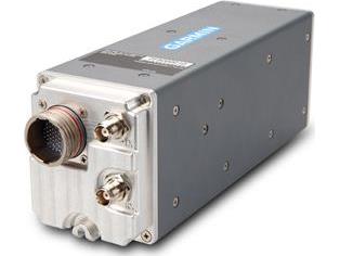
- Unit Height (with mounting rack): 3.99" (101.3 mm)
- Unit Width (with or without mounting rack): 3.02" (76.7 mm)
- Unit Depth (with mounting rack and connector): 11.62" (295.2 mm)
- Unit Depth (with mounting rack, connector and configuration module): 12.08" (306.9 mm)
- Unit Weight (with mounting rack): 3.5 lbs (1.6 kg)
- Typical Mating Circular Connector Weight: 0.13 lbs (0.06 kg)
- Typical Mating RF Connector Weight (2X): 0.07 lbs (0.03 kg) (weight listed is for 2 connectors)
- Operational Temperature Range: -55° C to +85° C
- Altitude Range: 55,000 ft maximum
- Software Compliance: RTCA/DO-178B Level B
- Hardware Compliance: Not Applicable - The GRA 5500 does not contain any complex or programmable logic devices
- Environmental Conditions: RTCA/DO-160F
- Altitude Accuracy: ± 1.5 ft (3 - 100 ft AGL); ± 2 % (> 100 - 2500 ft AGL)
- Altitude Range: -20 - 2550 ft AGL
- Altitude Alert Outputs Range: 0 - 2500 ft AGL
- Altitude Output Time Constant: 0.1 second maximum
- Transmitter Output: Frequency: 4.25 - 4.35 GHz "Gated" FMCW; Power: 1.0 W nominal
- Horizontal Velocity: 0 - 200 knots maximum
- Vertical Velocity: 20 ft/sec maximum (up to 100 ft AGL); 25 ft/sec maximum (above 100 ft AGL)
- Pitch Angle: ± 20° maximum
- Roll Angle: ± 20° maximum (with published altitude accuracy limits); ± 20° to ± 30° (with ± 20 % altitude accuracy limits throughout entire altitude range)
- Supply Voltage: 14/28 VDC
- Power Consumption: 13.75 W maximum (0.5 A at 27.5 VDC, 1.0 A at 13.75 VDC)


